Have you walked the 37 bridges of Paris?
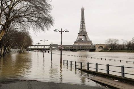
At the moment, Paris is having another one of those big floods (“inondations” in French). Well, if you have walked the 37 bridges of Paris, your knowledge about the “zouave” or more accurately, the zouave du Pont de l’Alma, may come in handy …
Weather reports in Paris refer to the ankle or the knee of the zouave (and in the great Paris flood of 1910, the water reached its neck and people had to use small boats in the streets of Paris). All Parisians know this, and all Parisians know the Alma bridge!
If you have walked the 37 bridges of Paris from east to west, you may remember that this is the 28th bridge, and this bridge is more than just a bridge. Parisians worry about flooding, and during flood season, or when Parisians hear about the threat of high water levels, everyone talks about the “zouave” which is a tiny sculpture of a soldier from Algeria that serves as a meter of how high the water level is.
The Seine is actually a 777-km-long (483 mi) river and an important commercial waterway within the Paris Basin in the north of France. Rising at Source-Seine, 30 kilometres (19 mi) northwest of Dijon in northeastern France, it flows through Paris and into the English Channel at Le Havre (and Honfleur on the left bank).
For Paris, the floods of this year are slightly less serious than those in early 2016 but many towns and villages outside of Paris have been severely impacted. Nonetheless, teenagers have reportedly been wakeboarding through the streets of Paris while the Bateaux Mouches that ply the Seine have been shut down.
Thankfully, none of the 37 bridges are damaged as far as we know.
Follow Madeleine walking the 37 bridges of Paris, or bring Madeleine goes to Paris with you on your next trip!
Or enjoy some of the other blogs about Paris: http://madeleinetravels.com/paris/


